It’s hard, as individual property owners, to embrace the impact that a single decision - like proceeding with a project before permit approval - has on our surroundings. The effect isn’t immediate, and it isn’t a direct reaction to our choices. It takes time for the chain reaction to play out. Ask the 5, 10, 15, and 20-year residents whether Hayden Lake's water is as clear, or the bottom as sandy, or the shoreline as raw and unfettered as it used to be.
Two Projects, One Impact
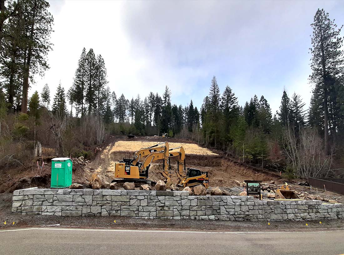
Starting last November, construction began on a new dual home-site, set back from the eastern shore of Hayden Lake. The homes are sure to be things of beauty, comfortable, and inviting places to live for their future residents. From their windows, people are likely to glimpse, through the trees, the sparkling lake waters below. That is, as long as the lake is there and as long as the water is sparkling.
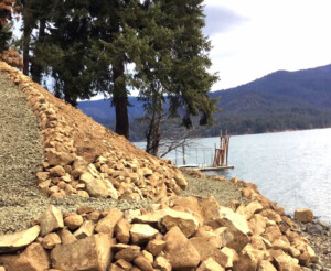
Months earlier, in the spring, smaller-scale construction began on a property improvement project on the lake’s western shore. The new property configuration is likely to open the view of the lake to the up-slope homeowner’s eyes; it may also provide an obstruction-free, gentle-sloping switchback path from the home down to the shoreline. That is, as long as the shoreline is there and as long as it’s attractive to foot-traffic.
Neither project started with a permit.
These two projects hold in common their unsuspecting impact on the views and environment that bring the homeowners to this special place to begin with.
What happens when we remove natural vegetation or dig into the hillside?
Weather happens! Rain falling on the land either soaks into the earth or runs off. In doing so, it transports soil, including the minerals and nutrients in it, down-hill or into the ground. The wind blows across the landscape. It picks up whatever is unattached and lighter than the force it wields.
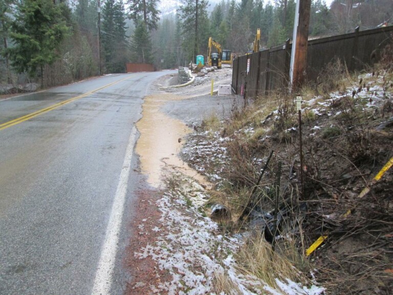
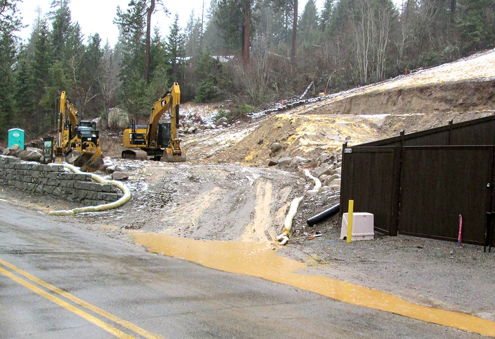
This recent construction site experience illustrates how having insufficient protections in place can catch even contractors by surprise. A rain-on-snow event, the worst kind for runoff and erosion, carried unprecedented amounts of sediment off the site, into a Highway District culvert (just off the lower right corner of the picture), under the road, and down the slope toward the lake about 200 ft below. With a properly executed permitting process, the County and contractor would have been able to ensure best management practices were in place to avoid this damage.
When we disturb the natural contours of the land or the native vegetation, we free the soil, once held in place by ground-cover, to move about the watershed. Runoff now meanders among the plant stems and roots, slowing and dropping sediment at every encounter. It flows unencumbered over loose soil, picks up speed, and carries a more massive load than before. The wind, minus vegetation to impede its path and absorb its energy, picks up and moves a more significant load as well. When the natural environment has been disturbed and human-made protections aren’t in place, that extra sediment picked up by water and wind is very likely to end up in the lake.
The dominoes do fall.
In the Hayden Lake Watershed, there are, of course, situations and locations where we have to dig up the soil and plants. Never-the-less, when we do it without proper precautions (1), soil and nutrient transport increase, and the resulting sediment pollutes the water. The lake that we love is a living system that feels the impact of increased sedimentation (2), as do we:
Clear, glass-like water becomes clouded.
Silt fills in and covers the sand and gravel lake-bottom.
Nutrients feed the growth of aquatic plants and algae.
Water temperature rises.
Fish populations shift – their habitat has changed.
To protect property, surface water, and groundwater against significant adverse effects from excavation, filling, clearing, unstable earthworks, soil erosion, sedimentation, and stormwater collection and runoff;
To protect property, surface water, and groundwater against significant adverse effects from excavation, filling, clearing, unstable earthworks, soil erosion, sedimentation, and stormwater collection and runoff;
Nobody wants to damage the environment that attracted us to Hayden Lake. We have the Kootenai County Land Use Development Code (the Code) to help us avoid doing just that. The Code specifies that no sediment may leave a project site. It reminds us of what we need to do and how we need to protect the environment while we complete our projects. The permitting process outlined in it is systematic and easy to follow. The Code also describes the actions to be taken to preserve a shoreline management area 25 feet wide, above the lake’s OHWM:
Without maintaining a 25-foot shoreline management area, a home site could allow runoff of sediment and nutrients to flow into the lake. This informative document from Kootenai County can help homeowners manage their property and protect the lake: Shoreline Management Areas.
Shoreline Management Area:
“Special consideration of this area is provided herein to ensure that prior to, during, and after construction operations, water quality, aquatic habitat, and property are protected, while recognizing the rights of property owners to have appropriate use of their property and to be able to protect their property from erosion.” (See Section 8.7.111 of the Kootenai County Land Use and Development Code.)
According to the Code, a site disturbance permit is required for all ground-disturbing, excavating, and grading activities. This is true even on your private property. There are a few exceptions, like installing a reasonable-sized garden. And there are exceptions to the exceptions, i.e., not within 25 feet of the shoreline or 75 feet of a class 1 stream. Whether your project requires a permit or qualifies as an exception, your job is to prevent sediment from leaving the project site. If you’re planning to modify your property, please contact Kootenai County Community Development via the form or phone number on their webpage. Include erosion control in your planning. And secure your site disturbance permit.
I tried to complain about the construction on HL rd to different agencies to no avail so glad to see it is finally being addressed.
Question I continue to have tho is about the boulders placed at the outlet which can only cause the MHW in the spring to be higher and to last longer, well into the wake surfing boat season. This will become critically important when small debris starts clogging the spaces between the boulders and cause the high water mark for the year to increase even more.
I totally agree with the permit process in the effort to avoid run off into the lake. What concerns me is why was the clear cut in Hayden Creek area allowed to happen. Seems to me this would be of more concern than just a single lot being excavated, as it’s a primary in-flow for the lake.
The mission of the Hayden Lake Watershed Improvement District is to protect and enhance the water quality and the environmental quality within the watershed.
HLWID's Monthly Meetings will move to teleconferencing in order to ensure the health and safety of our constituents. For 4/16's meeting, dial 641-715-0861 and enter code 398963# at the prompt.
This is a public meeting; all are welcome.


2 Responses
I tried to complain about the construction on HL rd to different agencies to no avail so glad to see it is finally being addressed.
Question I continue to have tho is about the boulders placed at the outlet which can only cause the MHW in the spring to be higher and to last longer, well into the wake surfing boat season. This will become critically important when small debris starts clogging the spaces between the boulders and cause the high water mark for the year to increase even more.
I totally agree with the permit process in the effort to avoid run off into the lake. What concerns me is why was the clear cut in Hayden Creek area allowed to happen. Seems to me this would be of more concern than just a single lot being excavated, as it’s a primary in-flow for the lake.
Comments are closed.